OSNI Aerial Photography
A detailed, bird’s-eye view of Northern Ireland
OSNI Aerial Photography
A detailed, bird’s-eye view of Northern Ireland
When you need the visual feel for a location in Northern Ireland, OSNI Aerial Photography gives you the real-world view.


OSNI Aerial Photography
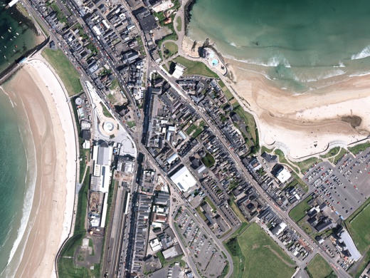
OSNI Aerial Photography offers a collection of 3-band images which provide a detailed, bird’s-eye view of the Northern Ireland landscape. The photography is captured in optimal weather conditions to provide the best possible images.
This impressive imagery product has many applications where a real-world view of the landscape is required, from which accurate measurements can be taken.
OSNI Aerial Photography is licensed annually and can be supplied either as a set of standardised tiles or as a fully bespoke area of interest.
Focus on quality
Captured at an altitude of 5000ft, each tile covers an area of 2400m × 1600m. Each pixel has a ground representation of 0.25m. The imagery is fully orthorectified to account for topographical variations in the earth’s surface. A vector layer is provided which includes the date the imagery was collected.
With complete coverage of Northern Ireland, the OSNI Aerial Photography is flown on a three-year cycle.


Available through viaEuropa
OSNI Aerial Photography is available through viaEuropa – the award-winning hosted map and API platform from Europa Technologies. As well as full coverage of Northern Ireland, the service can provide an integration with aerial photography for Great Britain, yielding full UK coverage.
viaEuropa delivers high quality, fully maintained, digital maps and location data directly to your web applications, desktop GIS and mobile apps. Use viaEuropa to drive location intelligent solutions quickly, easily and efficiently.
Our added value
By licensing Ordnance Survey Northern Ireland (OSNI) map data products through Europa Technologies, you will automatically receive the following benefits, usually charged additionally by many of our competitors:
- Free Data Life Support – any questions or issues with the product during the licence period, just ask!
- Broad range of formats available – We can deliver data in commonly used formats such as Esri File GeoDatabase, Esri Shapefile, MapInfo TAB and others.
- Expert advice from an award-winning OSNI Licensed Partner.
If you have a requirement for OSNI data, or are an existing licence holder and are considering a new supplier, please contact us.
Related products
Ordnance Survey Northern Ireland (OSNI) Map Data
OSNI Map Data products are produced by Ordnance Survey of Northern Ireland – the official mapping agency of Northern Ireland. OSNI is part of Land and Property Services (LPS), the government agency that collect, process and manage land and property information. They are the authoritative source of digital maps and data for Northern Ireland.

Bluesky Aerial Photography
Bluesky Aerial Photography provides you with a current, real-world view across Great Britain and Ireland. With an exceptional focus on quality, accuracy and consistency, this product can support location intelligence applications across a variety of disciplines.
Free data life support
All data products supplied by Europa Technologies include free, world-class, lifetime support.
Got a technical issue or licensing question? No problem – we’re just a call or an e-mail away.
Arrange your digital map licensing through us with the assurance of great value from your data investment.

How can we help you?
Ask an expert…
Do get in touch if you would like more details about OSNI Aerial Photography (technical, licensing, pricing, etc.) or would like to arrange a personalised demo. Our product specialists will be happy to provide you with a free consultation.

