What is a Gazetteer?
An introduction to the geographical index
What is a Gazetteer?
An introduction to the geographical index
What is a gazetteer? A gazetteer is a geographical index or directory used in conjunction with a map or atlas. Ancient Greek gazetteers are known to have existed since the Hellenistic era (323BC – 31BC). They became popular in Britain in the 19th century by several notable publishers, to meet public demand for information on the expanding Empire. The name was also a common title for newspapers (e.g. The York Gazetteer), but has fallen out of fashion in modern times.

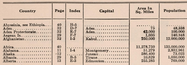
Typical entries from a paper-based global gazetteer
In the digital world, a gazetteer is commonly used with computer mapping and Geographical Information Systems (GIS) an index to cities, towns, villages, airports, ports and other points of interest. Names are stored with attributes such as location (a latitude/longitude coordinate) and sometimes statistics such as population.
One form of medieval gazetteer, was the Domesday Book. This Great Survey of much of England and parts of Wales was completed in 1086 by order of William the Conqueror. As an index of landownership and livestock, the survey’s main purpose was to determine what taxes had been owed during the reign of Edward the Confessor. The manuscript is now held at The National Archives at Kew, London. In 2011 the Open Domesday site made the manuscript available online.
A Modern Digital Gazetteer
Global 360
Global 360 is a global gazetteer in the form of a database containing over 980,000 locations. The product lists places, countries, administrative regions, islands, airports, ports, national parks, lakes and general points of interest (such as tourist locations). Global 360 is ideal for any business organisation that requires a consistent global location resource for web-based search, geo-coding and reverse geo-coding. It includes support for localisation and forms a valuable component of any enterprise-wide Spatial Data Infrastructure (SDI). What is a gazetteer? Global 360 is the global gazetteer!


