OSNI Pointer
Delivering location intelligent addressing for Northern Ireland
OSNI Pointer
Delivering location intelligent addressing for Northern Ireland
OSNI Pointer is the address database for Northern Ireland and the standard address for every property. Land & Property Services (LPS) maintains the database with help from local councils and Royal Mail.
OSNI Pointer
OSNI Pointer is the definitive data set for all properties in Northern Ireland with comprehensive coverage. Importantly it can reveal information on multiple occupancy and building use. The Unique Property Reference Number (UPRN) assigned to each property from the national hub, ensures consistency of referencing across Northern Ireland and Great Britain.
OSNI Pointer data include Irish Grid coordinates and is available as full Northern Ireland coverage or supplied by council district area.
Rich, definitive addressing
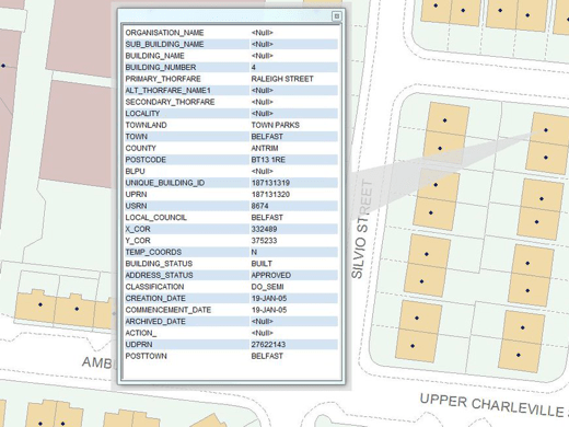
OSNI Pointer data is the definitive spatial address database for Northern Ireland and can be used to improve the quality of your address data for the nation. It includes a unique reference for each address (the UPRN) which can be used to link together data from different sources. Pointer data is available for the whole of Northern Ireland, and can also be supplied by council district area. It uses the Irish Grid coordinate system, for consistency with other data you may hold for Northern Ireland (although we can also supply the data in alternative coordinate systems if required). Pointer data also incorporates the official townland names, and includes alternative road names in Irish or Ulster Scots if approved by the local council. There is also an optional extension file containing ward names and parliamentary constituency information.

Improve address data quality
Pointer data can be used in a geocoding solution in order to assign coordinates to your data, thereby enabling spatial analysis and the visualisation of your data in a mapping application. It can also be used to cleanse the addresses you hold against the master address data for Northern Ireland, thereby improving your data quality and facilitating more accurate analysis.
Use the UPRN included for every address to link data to multiple disparate data sets, thereby reducing data duplication, maintaining data currency and simplifying data sharing.
Our added value
By licensing Ordnance Survey Northern Ireland (OSNI) map data products through Europa Technologies, you will automatically receive the following benefits, usually charged additionally by many of our competitors:
- Free Data Life Support – any questions or issues with the product during the licence period, just ask!
- Broad range of formats available – We can deliver data in commonly used formats such as Esri File GeoDatabase, Esri Shapefile, MapInfo TAB and others.
- Expert advice from an award-winning OSNI Licensed Partner.
If you have a requirement for OSNI data, or are an existing licence holder and are considering a new supplier, please contact us.
Related products
Ordnance Survey Northern Ireland (OSNI) Map Data
OSNI Map Data products are produced by Ordnance Survey of Northern Ireland – the official mapping agency of Northern Ireland. OSNI is part of Land and Property Services (LPS), the government agency that collect, process and manage land and property information. They are the authoritative source of digital maps and data for Northern Ireland.
AddressHub
AddressHub is an address product for Great Britain built upon definitive Royal Mail Postcode Address File (PAF®) data, enhanced with UPRN (Unique Property Reference Number), coordinates and other valuable attributes. Designed to deliver a cost-effective addressing capability to organisations of any size, AddressHub opens the door to connect databases from multiple sources. Search, locate and identify addresses with ease and precision.
Free data life support
All data products supplied by Europa Technologies include free, world-class, lifetime support.
Got a technical issue or licensing question? No problem – we’re just a call or an e-mail away.
Arrange your digital map licensing through us with the assurance of great value from your data investment.
How can we help you?
Ask an expert…
Do get in touch if you would like more details about OSNI Pointer (technical, licensing, pricing, etc.) or would like to arrange a personalised demo. Our product specialists will be happy to provide you with a free consultation.


