OS MasterMap Water Network
Every river, stream, lake and canal in Great Britain
OS MasterMap Water Network
Every river, stream, lake and canal in Great Britain
OS MasterMap Water Network is the only detailed, heighted water network of Great Britain showing the flow and precise course of rivers, streams, lakes and canals. It supports flood risk management and is ideal for data sharing.
OS MasterMap Water Network
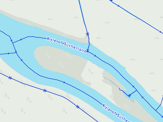
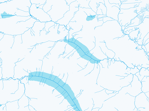
From aqueducts to tunnels, with annotations of flow direction, OS MasterMap Water Network Layer provides the detailed mapping that’s most useful – including underground watercourses (inferred from entry and exits).
Proximity is key. Organisations can understand water-related risks in detail, combining OS MasterMap Water Layer with OS MasterMap Topography Layer, property information and 3D height data for even richer insights.
For planners, for surveyors, for engineers – this Layer offers the potential to model in 2D and 3D like never before, thanks to the clarity of river flow, gradient and river widths.
OS MasterMap Water Network is released quarterly in January, April, July and October.
Answers on tap
With OS MasterMap Water Network, you can look up the height of any water course, along with its flow direction, gradient, length and width anywhere along its length.
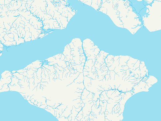
As an island, water defines Great Britain. No other visualisation of our nation’s watercourses details the heights of watercourses in relation to sea level with this level of precision.
OS MasterMap Water Network provides a detailed centre line following the curve of the waterway precisely. It includes the coordinates of watercourse sources and where they meet, exactly.


Potential applications
OS MasterMap Water Network supports a wide range of customers applications, including:
- Flood risk understanding
- Flood risk mitigation planning
- Flood response planning and execution
- Environmental impact analysis
- Tracing of contamination
- Asset management and protection
- Detailed flood modelling for insurance and land & property
Documentation & Resources
As part of our support for OS MasterMap Water Network, we provide a full, up-to-date library of documentation and resources, including product guides and technical specifications.

Related products
OS MasterMap Topo
The OS MasterMap Topography Layer, more commonly known as OS MasterMap Topo, is the most detailed and accurate view of Great Britain’s landscape – from roads and fields, to buildings, trees, fences, paths and more. In a business of any kind, OS MasterMap Topo will enable you to make assured location-based decisions about your assets, services, environmental risks, customers and operations.
Ordnance Survey (OS) map data
OS map data includes a wide range of digital maps and data products from Ordnance Survey – the national mapping agency for Great Britain. It produces and manages data of unparalleled depth, breadth and accuracy, maintaining the definitive record of Britain’s geographic features, relied on by government, business and individuals.
Our added value
A managed OS data supply provides you with expert licensing, a secure delivery platform and the first-class support services needed to optimise value from Ordnance Survey data within your organisation. By working with Europa Technologies, you will automatically receive the following benefits, charged as optional extras by many of our competitors:
- Free consultation – an opportunity to discuss your precise requirements and tailor a bespoke solution.
- Free support – If you have any questions or issues with the product during the licence period, just ask! Our support team is ready to help you.
- Broad range of formats – Ordnance Survey supply their products in limited formats but we can convert into all common GIS and CAD formats such as GeoPackage, MapInfo TAB, Esri Shapefile, Esri File GeoDatabase, Autodesk DWG and others. For many data formats, deliveries can also include our award-winning cartographic styling.
- Expert advice – From an award-winning Ordnance Survey Strategic Partner and Ordnance Survey Accredited Consultant.
If you have a requirement for Ordnance Survey data, or are an existing licence holder and are considering a new supplier, please contact us.
How can we help you?
Ask an expert…
Do get in touch if you would like more details about OS MasterMap Water Network (technical, licensing, pricing, etc.) or would like to arrange a personalised demo. Our product specialists will be happy to provide you with a free consultation.

