OS MasterMap Sites
The whole is greater than the sum of the parts
OS MasterMap Sites
The whole is greater than the sum of the parts
OS MasterMap Sites provides a consistent, nationally maintained view of the detailed extents and access points of important locations in Great Britain. The form and function nature of OS MasterMap Sites makes it suitable for risk modelling, business analysis and informed decision-making.

OS MasterMap Sites
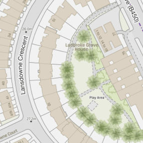
The OS MasterMap Sites features are a representation of what people see in the real world, where the common view of something (such as a school) is not the address, the main building or the playing fields, but is the site as a whole.
OS MasterMap Sites does not indicate the definitive or legal extent of a site, but rather the extent of usage or function, represented as polygons. Vehicular and pedestrian access points are also provided.
This product is updated every six months (April and October).
Convenient themes
OS MasterMap Sites covers seven practical themes:
- Air transport – airfield, airport, helicopter stations, heliport
- Education – first / infant / junior / middle / secondary schools, further / higher education and universities. Special needs education
- Medical care – hospice, hospital, medical care accommodation
- Rail transport – railway stations, vehicular rail terminal, tram station
- Road transport – coach stations, bus station, road user services
- Water transport – vehicular ferry terminal, passenger ferry terminal, port consisting of docks and nautical berthing
- Utility & industrial – chemical works, electricity distribution, electricity production, gas distribution or storage, oil distribution or storage, oil refining, oil terminal


Access all areas
As well as a polygon describing the extend of a site, OS MasterMap Sites contains access points. An access point refers to a functionally designed and maintained location where pedestrians and/or vehicles can enter or leave a site.
Access points are point features which are usually positioned on the boundary of the functional site extent to which they belong. They can also contain access information such as height and time or vehicular restrictions. The access point also references the nearest OS Highways Network link TOID. This allows the user to easily integrate the data with other OS datasets such as the OS MasterMap Highways.
Our added value
A managed OS data supply provides you with expert licensing, a secure delivery platform and the first-class support services needed to optimise value from Ordnance Survey data within your organisation. By working with Europa Technologies, you will automatically receive the following benefits, charged as optional extras by many of our competitors:
- Free consultation – an opportunity to discuss your precise requirements and tailor a bespoke solution.
- Free support – If you have any questions or issues with the product during the licence period, just ask! Our support team is ready to help you.
- Broad range of formats – Ordnance Survey supply their products in limited formats but we can convert into all common GIS and CAD formats such as GeoPackage, MapInfo TAB, Esri Shapefile, Esri File GeoDatabase, Autodesk DWG and others. For many data formats, deliveries can also include our award-winning cartographic styling.
- Expert advice – From an award-winning Ordnance Survey Strategic Partner and Ordnance Survey Accredited Consultant.
If you have a requirement for Ordnance Survey data, or are an existing licence holder and are considering a new supplier, please contact us.
Related products

viaEuropa
viaEuropa is the award-winning hosted map and API platform from Europa Technologies. It delivers high quality, fully maintained, digital maps and geodata directly to your web applications, desktop GIS and mobile apps. Use viaEuropa to drive location intelligent solutions quickly, easily and efficiently.
viaEuropa supports a variety of high-quality content from Ordnance Survey, Ordnance Survey Northern Ireland, Bluesky International, Government of Jersey, JBA Risk Management, British Geological Survey, MB International and OceanWise.
OS MasterMap Topo
The OS MasterMap Topography Layer, more commonly known as OS MasterMap Topo, is the most detailed and accurate view of Great Britain’s landscape – from roads and fields, to buildings, trees, fences, paths and more. In a business of any kind, OS MasterMap Topo will enable you to make assured location-based decisions about your assets, services, environmental risks, customers and operations.
Ordnance Survey (OS) map data
OS map data includes a wide range of digital maps and data products from Ordnance Survey – the national mapping agency for Great Britain. It produces and manages data of unparalleled depth, breadth and accuracy, maintaining the definitive record of Britain’s geographic features, relied on by government, business and individuals.
OS MasterMap Sites – Documentation & Resources
As part of our support for OS MasterMap Sites, we provide a full, up-to-date library of documentation and resources, including product guides, technical specifications and other files to help you work with this comprehensive data product.

How can we help you?
Ask an expert…
Do get in touch if you would like more details about OS MasterMap Sites (technical, licensing, pricing, etc.) or would like to arrange a personalised demo. Our product specialists will be happy to provide you with a free consultation.

