OS MasterMap Imagery
Your real-world view of Great Britain
OS MasterMap Imagery
Your real-world view of Great Britain
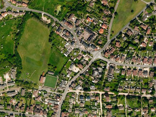
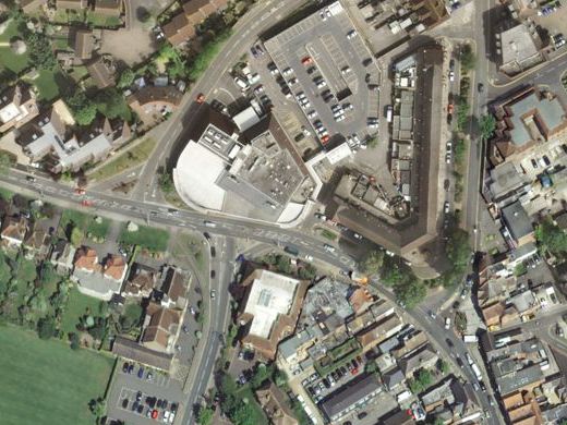
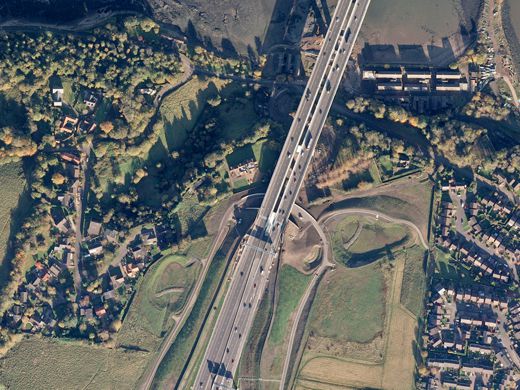
When you need the visual feel for a location, the aerial photography of OS MasterMap Imagery Layer gives you the real-world view.
OS MasterMap Imagery
Using OS MasterMap Imagery to check road markings, tree canopies or site entrances cuts down the need for site visits, so you can save money and manage time more efficiently. For engineers, for surveyors, for planners, this product is a revelation. With 25cm resolution, it is aligned to OS MasterMap Topo and is incredibly detailed, expertly colour-balanced and corrected for geometric distortions.
OS MasterMap Imagery is an off-the-shelf product for the whole of Great Britain and available in JPEG, TIFF and ECW formats. It is released quarterly in February, May, August and November.
Focus on quality
Ordnance Survey has invested considerable resources and worked closely with its imagery suppliers to provide orthorectified imagery that achieves the consistently high quality expected by our customers.
Unlike other data sources, such as topographic data, imagery can be very subjective. It is difficult to quantify specific tolerances for atmospheric conditions, such as haze. Ordnance Survey ensures that their suppliers adhere to a detailed set of quality levels for the key aspects of imagery with an emphasis on data quality over image appearance alone. For instance priority is given to ensuring detail such as road markings can be seen within shadows and to positional accuracy.
OS MasterMap Imagery is fully orthorectified to provide a high level 1.1m RMSE (Root Mean Squared Error) accuracy and correct alignment with other detailed OS data products.


Up-to-date imagery
OS MasterMap Imagery uses the same source imagery that underpins data updates for other large-scale OS products. More than 97% of OS MasterMap Imagery is less than five years old; 90% is less than three years old. Contact us to check imagery currency for your area of interest.
Each OS MasterMap Imagery tile is accompanied by a separate XML metadata file in a consistent format across every image in the layer. The metadata is extremely detailed and includes information ranging from imagery capture date to photographic lens focal length.
Our added value
A managed OS data supply provides you with expert licensing, a secure delivery platform and the first-class support services needed to optimise value from Ordnance Survey data within your organisation. By working with Europa Technologies, you will automatically receive the following benefits, charged as optional extras by many of our competitors:
- Free consultation – an opportunity to discuss your precise requirements and tailor a bespoke solution.
- Free support – If you have any questions or issues with the product during the licence period, just ask! Our support team is ready to help you.
- Broad range of formats – Ordnance Survey supply their products in limited formats but we can convert into all common GIS and CAD formats such as GeoPackage, MapInfo TAB, Esri Shapefile, Esri File GeoDatabase, Autodesk DWG and others. For many data formats, deliveries can also include our award-winning cartographic styling.
- Expert advice – From an award-winning Ordnance Survey Strategic Partner and Ordnance Survey Accredited Consultant.
If you have a requirement for Ordnance Survey data, or are an existing licence holder and are considering a new supplier, please contact us.
Related products
OS MasterMap Topo
The OS MasterMap Topography Layer, more commonly known as OS MasterMap Topo, is the most detailed and accurate view of Great Britain’s landscape – from roads and fields, to buildings, trees, fences, paths and more. In a business of any kind, OS MasterMap Topo will enable you to make assured location-based decisions about your assets, services, environmental risks, customers and operations.
Ordnance Survey (OS) map data
OS map data includes a wide range of digital maps and data products from Ordnance Survey – the national mapping agency for Great Britain. It produces and manages data of unparalleled depth, breadth and accuracy, maintaining the definitive record of Britain’s geographic features, relied on by government, business and individuals.
Documentation & Resources
As part of our support for OS MasterMap Imagery Layer, we provide a full, up-to-date library of documentation and resources, including product guides and technical specifications.

How can we help you?
Ask an expert…
Do get in touch if you would like more details about OS MasterMap Imagery (technical, licensing, pricing, etc.) or would like to arrange a personalised demo. Our product specialists will be happy to provide you with a free consultation.

