OS MasterMap Highways Network
A detailed, accurate and up-to-date road routing network for Great Britain
OS MasterMap Highways Network
A detailed, accurate and up-to-date road routing network for Great Britain
OS MasterMap Highways Network provides all the highways data you need, in one place. It’s a new, common and authoritative view of the whole road network in Great Britain, ideal for routing and public sector data-sharing.
OS MasterMap Highways Network
For all highways stakeholders, OS MasterMap Highways Network is data you can trust. It draws on authoritative sources and helps underpin the common operational picture that leads to faster, better decisions.
A common highways data set means a common understanding of where incidents are happening, and what’s happening in the surrounding area. OS MasterMap Highways Network – Roads will give you detailed information about planned roads and roads under construction, helping you to better understand the roads of today and the roads of tomorrow.
OS MasterMap Highways Network is updated and released monthly.
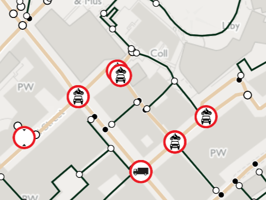
Turn restrictions
In OS MasterMap Highways Network, the restriction information is not applied to the base network, but is referenced. This allows the range of information collected to be extended in the future and minimise the impact on customers not concerned with routing information. The main categories of restriction information captured are as follows:
- One way
- No entry
- Access restrictions
- Height restrictions
- Turn restrictions
- Mandatory turns
To whom the restrictions apply and any time constraints are also captured.


Essential links
Thanks to the Unique Street Reference Number (USRN), this data links to OS AddressBase so you can search for or navigate to an address, improve consultation about roadworks, and identify installations like electricity substations.
The Road layer of OS MasterMap Highways Network is designed to work with OS MasterMap Topography Layer, joining together the best from Ordnance Survey products. Highways Network focuses on joining the topographic identifiers (TOIDs) between these products to enable various applications, from doorstep deliveries to managing streetworks and capital assets more effectively.
Our added value
A managed OS data supply provides you with expert licensing, a secure delivery platform and the first-class support services needed to optimise value from Ordnance Survey data within your organisation. By working with Europa Technologies, you will automatically receive the following benefits, charged as optional extras by many of our competitors:
- Free consultation – an opportunity to discuss your precise requirements and tailor a bespoke solution.
- Free support – If you have any questions or issues with the product during the licence period, just ask! Our support team is ready to help you.
- Broad range of formats – Ordnance Survey supply their products in limited formats but we can convert into all common GIS and CAD formats such as GeoPackage, MapInfo TAB, Esri Shapefile, Esri File GeoDatabase, Autodesk DWG and others. For many data formats, deliveries can also include our award-winning cartographic styling.
- Expert advice – From an award-winning Ordnance Survey Strategic Partner and Ordnance Survey Accredited Consultant.
If you have a requirement for Ordnance Survey data, or are an existing licence holder and are considering a new supplier, please contact us.
Related products
OS MasterMap Topo
The OS MasterMap Topography Layer, more commonly known as OS MasterMap Topo, is the most detailed and accurate view of Great Britain’s landscape – from roads and fields, to buildings, trees, fences, paths and more. In a business of any kind, OS MasterMap Topo will enable you to make assured location-based decisions about your assets, services, environmental risks, customers and operations.
Ordnance Survey (OS) map data
OS map data includes a wide range of digital maps and data products from Ordnance Survey – the national mapping agency for Great Britain. It produces and manages data of unparalleled depth, breadth and accuracy, maintaining the definitive record of Britain’s geographic features, relied on by government, business and individuals.
Documentation & Resources
As part of our support for OS MasterMap Highways Network, we provide a full, up-to-date library of documentation and resources, including product guides and technical specifications.

How can we help you?
Ask an expert…
Do get in touch if you would like more details about OS MasterMap Highways Network (technical, licensing, pricing, etc.) or would like to arrange a personalised demo. Our product specialists will be happy to provide you with a free consultation.

