National Tree Map
The most comprehensive tree database for GB & Ireland
National Tree Map
The most comprehensive tree database for GB & Ireland
The National Tree Map™ is the foremost environmental database of its kind. With coverage across Great Britain and Ireland, it contains the location, height and canopy/crown extents for trees 3m and above in height.
“He is a fool who looks at the fruit of lofty trees, but does not measure their height”
– Quintus Curtius Rufus

National Tree Map
Trees are vital to our environment and well-being – improving the air we breathe, providing valuable habitats for wildlife and conserving energy by naturally cooling nearby buildings.
The proximity of trees to buildings, utilities networks and subterranean assets can, however, pose significant risk through subsidence or pipeline fractures, root damage and destruction caused by falling trees and branches. It is a priority that those involved in tree and vegetation management have access to the most accurate and comprehensive data available.
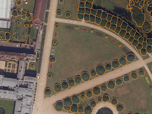
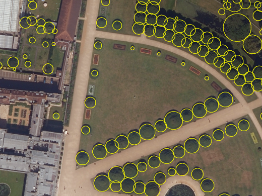
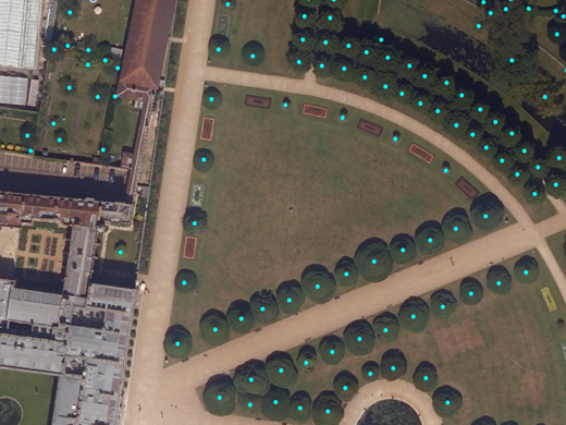
Rich specification
The National Tree Map, produced by Bluesky International, is created from high-resolution aerial photography, accurate terrain and surface data plus colour infrared imagery, combined with innovative processing techniques. For all trees over 3m in height, the database includes measurements of location, height and canopy/crown spread.
This comprehensive product is delivered in three layers:
- Polygons representing tree canopies
- Idealised circular shaped crowns
- Height point
The National Tree Map is updated regularly as new aerial photography becomes available through a cyclic update programme.

A wealth of applications
The National Tree Map is used to meet challenges across various market sectors. Its importance is not limited to forestry, environmental management and government planning. It is a valuable tool for insurers in the mitigation of risk posed by subsidence, flood and structural damage. Transportation networks rely on tree data to avoid disruption and damage caused by falling trees and even leaf-fall. All utilities will value this resource for the maintenance of subterranean assets as well as those above ground, such as powerlines (illustrated).
The database is an essential reference asset in planning and managing our future environments, both rural and urban.
Beautifully visualised
In addition to supply in all common GIS formats, the National Tree Map can be accessed as an overlay with our award-winning viaEuropa service. Featuring beautiful cartography, the product can be visualised over imagery or base maps such as OS VectorMap Local and OS MasterMap Topography layer.
viaEuropa even supports a special treeless version of OS MasterMap Topography layer which has all positioned trees and woodland fill symbols removed. This forms an ideal background for the National Tree Map.

Related products

Risks & Perils
A portfolio of geo-referenced risks & perils data with models for events including flood, subsidence, political risk and climate change. Serving more than just insurers, these products help you evaluate risk to property and assets, improve readiness and bolster your ability to respond and mitigate.

Bluesky Aerial Photography
Bluesky Aerial Photography provides you with a current, real-world view across Great Britain and Ireland. With an exceptional focus on quality, accuracy and consistency, this product can support location intelligence applications across a variety of disciplines.
Free data life support
All data products supplied by Europa Technologies include free, world-class, lifetime support.
Got a technical issue or licensing question? No problem – we’re just a call or an e-mail away.
Arrange your digital map licensing through us with the assurance of great value from your data investment.

How can we help you?
Ask an expert…
Do get in touch if you would like more details about National Tree Map (technical, licensing, pricing, etc.) or would like to arrange a personalised demo. Our product specialists will be happy to provide you with a free consultation.

