EstateHub
Adding location intelligence to the HM Land Registry NPS
EstateHub
Adding location intelligence to the HM Land Registry NPS
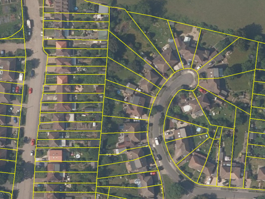
EstateHub is a land coverage product for England & Wales built upon the authoritative HM Land Registry National Polygon Service (NPS). It includes polygons defining all registered freehold and leasehold land parcels, including title number, property UPRNs, significantly enhanced with additional attributes which give depth and context to estate-based searches.


EstateHub – discover the lie of the land
EstateHub is a comprehensive database of registered land in England and Wales, derived from the authoritative HM Land Registry National Polygon Service (NPS), which incorporates the National Polygon Dataset (NPD). It includes a polygon layer containing title number and tenure information, alongside look-up tables linking to Unique Property Reference Numbers (UPRN) and domestic/foreign company ownership information.
EstateHub has been designed to provide the definitive lie of the land and act as a gateway to ownership information from HM Land Registry reports.
Locate, identify and understand land ownership with ease and precision using EstateHub.
Land, addresses, aerial & maps – a winning combination
Many applications can benefit from EstateHub combined with other data products, such as definitive address databases, rich aerial photography, and detailed Ordnance Survey maps. For example, insurance companies can identify potential risks across both site and property at a given address. In telecommunications, network operators deploying full fibre broadband can identify land access required and (through HM Land Registry reports) approach landowners with lease or wayleaving propositions.
We can offer great value data bundles for your area of interest. Can we find a winning combination for your organisation?


Land data made easy
EstateHub is available in a range of commonly used GIS data formats including GeoPackage, Esri File Geodatabase and MapInfo TAB Extended.
EstateHub can be supplied for the whole of England & Wales, by local authority or fully bespoke area. Licensed annually and with monthly updates available, EstateHub offers comprehensive, up-to-date intelligence and excellent value for money.
Looking to consume land data as a service? Our viaEuropa platform can deliver EstateHub as a high-performance API.
A foundation for PropTech
With comprehensive coverage of England and Wales, EstateHub is ideal as a core reference database for land and property intelligence applications. It will give you a fuller picture of land registration in a given area.
The powerful combination of UPRN and location connects properties across multiple databases, enabling data analytics and revealing insights that can underpin crucial decision and policy making.
What would you like to discover about a specific property, estate or neighbourhood?

Related products
AddressHub
AddressHub is an address product for Great Britain built upon definitive Royal Mail Postcode Address File (PAF®) data, enhanced with UPRN (Unique Property Reference Number), coordinates and other valuable attributes. Designed to deliver a cost-effective addressing capability to organisations of any size, AddressHub opens the door to connect databases from multiple sources. Search, locate and identify addresses with ease and precision.
europaIQ
europaIQ offers valuable property intelligence data for Great Britain in a variety of pragmatic categories. Whether you are an owner, investor, developer or manager, europaIQ provides invaluable intelligence about properties and their surrounding area. For both commercial and residential properties, a wide variety of data is available which can meet challenges, improve decision-making and reduce risk.
viaEuropa
viaEuropa is the award-winning hosted map and API platform from Europa Technologies. It delivers high quality, fully maintained, digital maps and geodata directly to your web applications, desktop GIS and mobile apps. Use viaEuropa to drive location intelligent solutions quickly, easily and efficiently.
viaEuropa supports a variety of high-quality content from Ordnance Survey, Ordnance Survey Northern Ireland, Bluesky International, Government of Jersey, JBA Risk Management, British Geological Survey, MB International and OceanWise.
Free data life support
All data products supplied by Europa Technologies include free, world-class, lifetime support.
Got a technical issue or licensing question? No problem – we’re just a call or an e-mail away.
Arrange your digital map licensing through us with the assurance of great value from your data investment.
How can we help you?
Ask an expert…
Do get in touch if you would like more details about EstateHub (technical, licensing, pricing, etc.) or would like to arrange a personalised demo. Our product specialists will be happy to provide you with a free consultation.


