Global Discovery
The new world in digital mapping
Global Discovery
The new world in digital mapping
Global Discovery extends the topographic base map of Global Insight Plus with additional layers of physical mapping to form a comprehensive and flexible map of the world. It is our ultimate product to support global location intelligence applications within your organisation.
Global Discovery
Global Discovery is the most comprehensive digital map of the world from Europa Technologies. It contains a comprehensive set of layers which support the production of both topographical and physical maps.
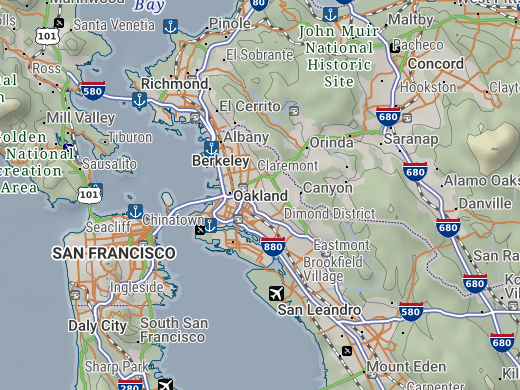
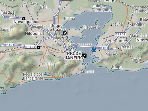
This data-rich product features vector reference mapping at 1:1,000,000 scale for the entire world. Coverage is provided by a manageable set of layers including over 2 million place names, points of interest, up-to-date political maps (1:1m & 1:3m scale), coastlines, international borders, some first and second level administrative borders, time zones, roads, railways, drainage features (rivers and lakes), national parks, airports (including IATA code) and ports (including UN/LOCODE). The elevation layers include polygon bands in metre and feet-based increments plus land contours and a mountain gazetteer.
You can see a showcase of 1000 digital maps created with this product in the Global 1000 Atlas which explores the 1000 most populated places in the world.
Rich attribute data
The map layers in Global Discovery feature rich attribute data to help improve cartography, perform better searches and enable analytical functions. For example, the extensive places gazetteer grades all locations from capital down to small village or settlement. Many cities and towns include an estimated population. The airports layer includes name, type, IATA code and ICAO code. Similarly, the ports layer includes name and UN/LOCODE.
The combination of worldwide coverage and rich attribute data make Global Discovery a formidable supplement to your data assets.


An enterprise-ready data asset
Global Discovery is ready to deploy on corporate servers, both dedicated and cloud based. It can form the backbone to a Global Spatial Data Infrastructure (GSDI) and deliver access to the geographic information required to power location intelligence applications in your organisation.
If your operations are international or worldwide, use Global Discovery as a core data asset to support operational awareness, empower analysis, bolster decision making, allocate resources, meet standards and justify policy-making.
New in Global Discovery 2024.2
Version 2024.2 was released in June 2024 and includes:
- Addition of Esri ArcGIS Pro project files
- Addition of over 37,000 population estimates
- Updated time zones with DST for 2024/2025
- Expo: Updated earthquakes database
- General maintenance and improvements

Rich map layers
Global Discovery consists of the following intermatching map data layers. Additionally, the product contains Expo – a curated set of guest content from trusted partners and carefully selected third parties.
Standard Content
- Political Land Masses
- Coastlines
- Political Reference
- International Borders
- 1st Level Administrative Reference
- 1st Level Administrative Borders
- 2nd Level Administrative Borders
- Places (1.6m+ with 2m+ names)
- Points of Interest (POI)
- Urban Sprawls
- Time Zones with DST
- National Parks
- Deserts
- Sea Bathymetry
- Ocean Features
- Roads
- Railways / Railroads
- Drainage (Rivers & Lakes)
- Airports (inc. IATA & ICAO codes)
- Ports (inc. UN/LOCODE)
- Elevations
- Contours
- Mountains & Ranges
- Simple Grids
- Military Grid (MGRS)
- Superfund Grids
- Uber H3 Grids
- UTM Zones
- MARPOL 73/78, PSSA
- Antarctica claims
- Chinese nine-dash line
- Flag Images
Expo Content
- Shaded Relief
- Exclusive Economic Zones
- Earthquakes
- Tectonic Plates
- Flight Routes (unmaintained)
- NASA Blue Marble
- NASA Black Marble
- Monthly Cloud Cover (2023)
- Earth Gravitational Model (EGM2008) grid/raster
- Climate Change – Global Temperatures
- Köppen−Geiger Climate Classification
- UNESCO World Heritage List
A myriad of applications
There are an unlimited number of uses for Global Discovery. Potential applications include:
- General reference mapping
- Global geocoding by place name
- International strategic planning
- Travel planning & transportation tracking
- Telecommunications
- Mining, oil & gas exploration
- Place name overlay for satellite imagery


Data formats & delivery
Global Discovery is available in many popular GIS formats, including:
- Esri Shapefile
- Esri File GeoDatabase
- MapInfo TAB (Extended)
All data products are delivered using our secure data delivery platform, Europa Data Vault.
Flexible licensing
Global Discovery can be licensed for a single user, multiple users, server or corporate use. The product is provided subject to our standard End User Licence Agreement (EULA) for global data products. Additionally, attractive licensing terms are available to organisations who wish to integrate Global Discovery into their own software products and services.
Please contact us to discuss your specific requirements and request pricing information.

Related products
Global Map Data
Global map data is a cornerstone in the history of Europa Technologies. Our market-leading data products are the choice of SMEs, prestigious Fortune Global 500 companies, governments and missions of the United Nations. As a result of a long-standing integration with Google Earth and Google Maps, our global data products have been seen by over one billion people, approximately one in seven of the world’s entire population.
Free data life support
All data products supplied by Europa Technologies include free, world-class, lifetime support.
Got a technical issue or licensing question? No problem – we’re just a call or an e-mail away.
Arrange your digital map licensing through us with the assurance of great value from your data investment.

How can we help you?
Ask an expert…
Do get in touch if you would like more details about Global Discovery (technical, licensing, pricing, etc.) or would like to arrange a personalised demo. Our product specialists will be happy to provide you with a free consultation.

