Case Study – RSA
viaEuropa helps RSA streamline mapping applications
Case Study – RSA
viaEuropa helps RSA streamline mapping applications
Executive summary and key facts
With a 300-year heritage, RSA is one of the world’s leading multinational insurance groups. Focussing on general insurance, RSA’s core markets are the UK and Ireland, Scandinavia and Canada with the capability to write business across the globe. RSA has around 13,500 employees across its core business serving over 9 million customers in more than 100 countries. Its focus on general insurance has delivered strong, profitable performance, even in the most challenging market conditions. In 2015 its net written premiums were £6.8bn. The GeoRisk team is part of RSA’s Global Centre of Excellence and offers services across the whole of the RSA business. The team is headed up by Rob Osment, Global GeoRisk Director.

What was the business problem that needed to be solved?
There were two main issues that needed to be solved: one business related and one technical. RSA was seeking a solution to both.
Business problem
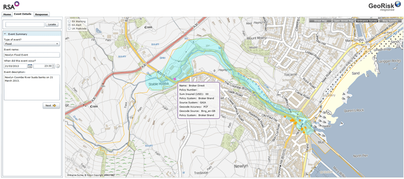
RSA had identified a need to replace the background maps it was using in its existing mapping applications for the visualisation of risk. Previously these had been Ordnance Survey rasters but whilst these gave a good visual representation they did not provide the additional intelligence that could be harnessed by the business. It was therefore decided that vector mapping was needed to enable the advanced analysis that was required. OS VectorMap Local was identified as being the best fit with the requirements. However, the raw data supplied by Ordnance Survey would need to be transformed into a finished base map and hosted appropriately before it could be shared with users.
Technical problem
Additionally, RSA had decided to overhaul its existing GIS environment, upgrading from a legacy internet mapping server to use the latest web mapping technology. However, the upgrade programme meant that existing mapping applications would no longer work and needed to be replaced. At this point it was necessary to consider whether it was best to continue to manage all web mapping services entirely in-house, or whether it was better to outsource the challenge of maintaining the environment and managing the data. After an initial review of the marketplace, RSA took the decision that it was more economic to outsource the provision of the Ordnance Survey base map services, but to keep the management and hosting of other data layers in-house.
What was the solution?
RSA chose to use the viaEuropa hosted map service from Europa Technologies to provide its users with access to the OS VectorMap Local base mapping they required. viaEuropa was one of the first hosted map services available for OS VectorMap Local. viaEuropa is an online service for the delivery of high quality digital maps direct to multiple applications. viaEuropa bridges the chasm between raw data delivery and a finished map product ready for deployment, making it ideal for RSA to deliver location intelligent applications whilst saving time, saving money and improving customer service. The service uses Europa Technologies’ years of expertise in map tile rendering to deliver high quality map tiles directly to a web mapping application or desktop GIS. The hosted service is an example of Data as a Service (DaaS) and uses high performance servers to provide a scalable level of performance as the number of users grows.
The viaEuropa service benefit ts include:
- Optimum performance
- Cartographic flexibility including Colour Vision Deficiency (CVD) support
- Consistent maps across different applications
- Quick and easy to implement
- Broad support for different applications and platforms
The viaEuropa service uses a combination of OS VectorMap Local, OS OpenData and global data from Europa Technologies to ensure that at each zoom level there is always an appropriate level of detail displayed. The service can also display OS MasterMap Topography Layer data where even more detail is required.
viaEuropa can be consumed using widely supported standards such as WMTS, TMS and WMS. Using a standards based approach ensures compatibility and ease of integration with multiple applications, as demonstrated by RSA’s use of the service.
viaEuropa bridges the chasm between raw data delivery and a finished map product ready for deployment, making it ideal for RSA to deliver location intelligent applications whilst saving time, saving money and improving customer service

Why was Europa Technologies selected?
Before selecting viaEuropa, RSA tested various services to evaluate their performance, ease of integration and overall user experience. Whilst other services proved technically challenging to connect to and use, viaEuropa was found to be very straightforward with a unique key for secure connections and a well-defined method for consuming the service. Additionally, RSA appreciated the customer centric approach of the Europa Technologies’ team, an example of which was providing an extended trial of the service that RSA could use in its Proof of Concept. Through this, RSA was able to thoroughly evaluate the service including rigorous performance testing and integration testing. In the words of Rob Osment, Global GeoRisk Director, RSA: “Our testing found the viaEuropa service to be very fast and reliable. It was a smooth transition to integrate the service into our applications, following the simple guidance from Europa Technologies. Considering the time and cost savings we have made by outsourcing this service, and the competitive pricing, it was a very easy decision to make.”
How was it implemented?
The implementation phase of the project was very fast, with integration of the viaEuropa service into industrial strength tools taking less than one day. Standard testing and deployment processes were then followed before making the service live. The RSA GeoRisk team includes experienced solution architects and software developers that take care of bespoke mapping applications. Adding the viaEuropa service to these tools was easy, as confirmed by Chris Smith, GeoRisk Lead Developer at RSA: “The viaEuropa web mapping tile service was easily integrated into our new and existing web mapping applications, achieved with only several lines of code. This ease of integration is down to the viaEuropa service being standards compliant and also the excellent support we have received from Europa Technologies.” Responding quickly to any customer issues was critical. An example of this arose when RSA scaled up its use of the service, resulting in some unexpected behaviour in the performance of the service. Through discussion between the RSA team and Europa Technologies, the cause of this was quickly identified and a fix applied within a matter of hours. Rob Osment again: “We found working with Europa Technologies to be a breath of fresh air. We particularly appreciated their responsiveness to our questions and requests.” In the desktop environment, whether using proprietary or open-source applications, RSA found that it was simple enough for users to configure access to the service themselves, just by pointing their GIS applications to the appropriate URL. Since then the service has been integrated into additional applications that were not expected at the outset. This has been easily achieved due to the use of widely supported standards (WMTS, TMS and WMS).
“The viaEuropa web mapping tile service was easily integrated into our new and existing web mapping applications”
What were the results?
This was RSA’s first foray into consuming geographic data as a service, rather than hosting it in-house. The fact that none of the end-users have noticed this fundamental change demonstrates the overall success of the project. They benefit from a reliable and responsive service, just as if the data was hosted internally. Users have also provided positive feedback on the cartography used within the service. For example, the clarity of the mapping and the consistent styling across all levels make it easy for underwriters to interpret the mapping and make timely decisions accordingly. The project has been a big success for the GeoRisk team, not just because of the quick integration, but because by outsourcing this piece it enables the team to become more efficient and focus their efforts where they are most needed. Importantly, it is also seen as a financial success as it means that RSA spends less on managing data, thereby enabling it to reallocate funding for better use elsewhere. This new approach also improves data accessibility globally across RSA. The existing intranet and WAN (Wide Area Network) were not designed for the delivery of large volumes of geographic data in real-time. By utilising this web-based approach, RSA can enable access to the same services right around the world if required. Overall the project is deemed to have exceeded expectations. Rob Osment once again: “Unfortunately great technology doesn’t always deliver the benefits it should due to a misalignment of people’s attitudes and motivations. We were delighted that Europa Technologies made sure that the viaEuropa service delivered all of the benefits we were promised, making this a pain-free experience for my team. Would we do this again? Absolutely!”
- End users did not notice that the data was no longer hosted internally.
- The cartography has been very well received.
- Both finance and personnel resources have been freed up and better utilised elsewhere.
- Data accessibility has been improved globally across RSA.

What are the next steps?
Looking ahead to the future, RSA anticipates the need to consume the base mapping in additional applications. As has already been demonstrated, the standards based approach of the viaEuropa service makes this simple and straightforward. Additionally, there may be requirements for base mapping for geographic regions outside of Great Britain (the scope of Ordnance Survey). Europa Technologies is already working with additional data providers to expand the portfolio of map data available through the viaEuropa hosted map service.
“We found working with Europa Technologies to be a breath of fresh air.
We particularly appreciated their responsiveness to our questions and requests.”
Looking back
Rob Osment looks back at the progress made since viaEuropa was first implemented by RSA in 2012: “Moving to viaEuropa for the delivery of mapping tile services was one of the most cost effective and beneficial changes that we have made. The purpose of a GeoRisk team is to help RSA underwriters understand geographic risk and to ensure that we have appropriate tools in place. In reality, as we use complex data within our tools we had become much too involved in data management and processing rather than working to identify new benefits which could be gained from the data itself. More recently we have moved to license some of our data sets through Europa Technologies and as part of that arrangement, the data is pre-processed to meet our requirements, so that implementation of updates has become much easier. Working with Europa Technologies has created the opportunity for us to listen to their ideas as to how we might extract more value from these data sets. We are seeing the manifestation of this commitment in the great applications that are being released to our users.”
About Europa Technologies
Europa Technologies offers a broad spectrum of products and services for the Insurance sector, ranging from a single piece of the jigsaw to a complete solution.
- Our managed data supply service includes data sets such as Ordnance Survey mapping for Great Britain and our own global CRESTA zones.
- The viaEuropa hosted map service (as used by RSA) can provide access to base mapping and perils data as a service.
- The Risk Insight platform provides a comprehensive risk assessment solution presenting a clear picture of risk and exposure across your organisation.
Europa Technologies is an award-winning specialist in digital maps and associated services for a wide variety of market sectors and applications. Our resources allow organisations with international interests to better understand their customers, assets and markets, in a geographic context, to gain a competitive or strategic advantage. Mapping products and services from Europa Technologies are used by many Fortune Global 500 companies, governments and missions of the United Nations. The company has global licence agreements with a number of leading Internet-based service providers including Google. Through deployment via Google Earth and Google Maps alone, our world data products have been seen by over 700 million people, approximately 1 in 10 of the world’s entire population. For further information on our products and services for the Insurance sector, including an obligation-free trial of the viaEuropa hosted map service, please contact us today.
How can we help you?
If you have any questions about this case study, please contact a member of our team who will be happy to help you.


